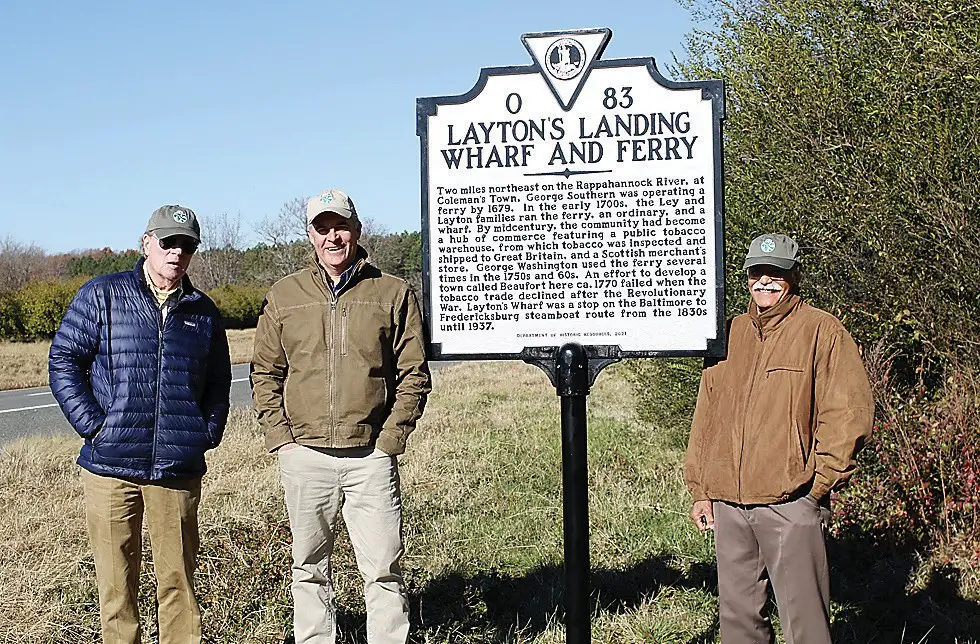
From left, Essex County Countryside Alliance President Peter Bance, Essex County Countryside Alliance Board member Sam Sturt, and Essex County North Election District Supervisor Sidney N. Johnson pose at a historical marker recognizing the contributions of Layton’s Landing Wharf and Ferry.
Thanks to a partnership between two local organizations, Essex County’s Colonial-era history is being recognized via the installation of two Historical Highway Markers along U.S. Route 17 in the Occupacia Rural Historic District.
Layton’s Landing Wharf and Ferry and Saunders’s Wharf markers were recently unveiled by representatives of the Essex County Conservation Alliance (ECCA), the driving force behind the project.
ECCA funded the effort, while the Essex County Museum and Historical Society assisted with details about the history of each location.
The Layton’s Landing Wharf marker is located at the intersection of Laytons Landing Road (Rte. 637) and Tidewater Trail (US 17), while the Saunders’s Wharf marker can be found at the intersection of Wheatland Road (Rte. 638) and Tidewater Trail (US 17).
The markers received approval from the Virginia Department of Historic Resources (DHR) and were erected by the Virginia Department of Transportation.
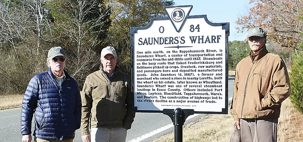
From left, Essex County Countryside Alliance President Peter Bance, Essex County Countryside Alliance Board member Sam Sturt, and Essex County North Election District Supervisor Sidney N. Johnson pose at historical markers recognizing the contributions of Saunders’s Wharf to the county’s history.
“Essex County has a deep history that goes back many, many years,” Essex County Countryside Alliance President Peter Bance. “This helps Essex County show the public its history in a visual way. These signs can be found all over Virginia and the more we can have in Essex County, I think the better it will be to attract visitors and tourists to come see our cherished land and houses..
“I think it’s very fascinating that we are able to reveal this history to youngsters who are coming along today,” said Essex Supervisor Sidney N. Johnson in whose district the markers are located. “This history is very profound and interesting.”
Layton’s Landing Wharf and Ferry in Essex County had a ferry operation as early as 1679. In the early 1700s, the Ley and Layton families ran a ferry, a tavern, and wharf there. By the mid-1700s, the community boasted a lively hub of commerce centering on a public tobacco warehouse. From the 1830s to 1937, Layton’s Wharf was a stop on a robust Baltimore to Fredericksburg steamboat route.
Saunders’s Wharf was also a stop on the busy steamboat route linking Fredericksburg and Baltimore. Situated along the Rappahannock River, Saunders’s Wharf operated between the mid-1800s and 1937, experiencing a lively trade in agricultural products, livestock, raw materials, and manufactured goods, and the comings and goings of passengers.
About three years ago, the ECCA agreed to sponsor two historical markers to be erected in the Occupacia Rural Historic District.
According to ECCA Board member Sam Sturt, a survey of markers along Route 17 “revealed there were no markers that referenced the Rappahannock River and its significance to Colonial Essex County or Colonial Virginia into the early 20th century.”
Sturt said ECCA then determined the markers would promote the river.
“That’s in keeping with the Essex County Conservation Alliance’s mission which is to promote and preserve the rural history of Essex County,” Sturt told the Rappahannock Times.
To comply with Virginia Department of Historic Resources guidelines, a significant event or place must be referenced.
“We decided to choose two of the more prominent wharves that were in the Occupacia Historic District,” Sturt explained. “The markers summarized the significance each wharf played in commerce, trade and moving people and business up and down the Rappahannock River from Colonial Virginia through the early 20th century when steamboats went out of favor and highway transportation took over.”
Sturt noted that ECCA could not have completed the project without the support of the Essex County Museum and Historical Society.
“They were very helpful in providing resource information and context for each marker,” Sturt said. “That material was submitted to the DHR for review and approval. Essex County museum members were critical in providing that text for each marker.”
The Virginia historical highway marker program documents facts, persons, events, and places prominently identified with the history of the nation, state, or region. DHR’s purpose in erecting markers is to educate the public about Virginia’s history, not to honor, memorialize, or commemorate persons, events, or places. Because highway markers are not honorific in nature, they do not serve the same purpose as monuments, statues, memorial plaques, or war memorials.
In 1966, management of the highway markers was transferred to the newly created Virginia Landmarks Commission, the predecessor agency of the Department of Historic Resources. Today VDOT retains primary responsibility for installing new markers and maintaining existing ones.
The text of each marker reads as follows:
Layton’s Landing
Wharf and Ferry
Two miles northeast on the Rappahannock River, at Coleman’s Town, George Southern was operating a ferry by 1679. In the early 1700s, the Ley and Layton families ran the ferry, an ordinary, and a wharf. By midcentury, the community had become a hub of commerce featuring a public tobacco warehouse, from which tobacco was inspected and shipped to Great Britain, and a Scottish merchant’s store. George Washington used the ferry several times in the 1750s and 60s. An effort to develop a town called Beaufort here ca. 1770 failed when the tobacco trade declined after the Revolutionary War. Layton’s Wharf was a stop on the Baltimore to Fredericksburg steamboat route from the 1830s until 1937.
Saunders’s Wharf
One mile north, on the Rappahannock River, is Saunders’s Wharf, a center of transportation and commerce from the mid- 1800s until 1937. Steamboats on the busy route that linked Fredericksburg and Baltimore picked up crops, livestock, raw materials, and passengers here and deposited manufactured goods. John Saunders (d. 1867), a farmer and merchant who owned a store in nearby Loretto, built the wharf on his estate, later known as Wheatland. Saunders’s Wharf was one of several steamboat landings in Essex County. Others included Port Micou, Layton’s, Blandfield, Tappahannock, Ware’s, and Bowler’s. The construction of highways led to the river’s decline as a major avenue of trade.
Loading Comments